St Arnaud Range Track
- 4 hr – 5 hr return by the same track
- Medium
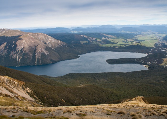
This walk climbs steadily through beech forest to a height of over 1650 metres. Above the bushline (at 1400 m), there are spectacular views from Parachute Rocks, which gained their name from a parachute‐shaped gravel scree located just to the north. The ridge is reached at 1700m with spectacular views of the surrounding area: Wairau Valley, Mt Richmond Forest Park, Kahurangi National Park, Buller Valley and Nelson Lakes National Park. There are several tarns on the east side. Return via the same route.
1 member favourited
1 member checked in
|
Walking time
|
1 day
4 hr – 5 hr
|
|---|---|
|
Distance
|
6.0km |
|
Type
|
Return by the same track
|
|
Grade
|
Medium
The last third of the track is very steep and care must be taken. Grades explained
|
|
Bookings
|
No bookings — open access
No — open access
|
|
Starts
|
The eastern corner of Kerr Bay, Lake Rotoiti |
|---|---|
|
Maps
|
NZTopo50-BS25
|
|
Altitude
|
620m
–
1,700m
Altitude change 1,080m
|
|
Link
|
www.doc.govt.nz/Documents/parks-and-recreation/tracks-and-walks/nelson-marlborough/nelson-lakes-short-walks-brochure.pdfhttp://www.doc.govt.nz/Documents/parks-and-recreation/tracks-and-walks/nelson-marlborough/nelson-lakes-short-walks-brochure.pdf |
|---|
Spectacular views from this range. The last third of this track can be hard on knees (both ascent/descent) and is exposed, especially the ridge which is narrow in places. Nice camping spots near the tarns.
ID 13451
About this track
66 views in the past year (6 per month).