Related
Hakatere Conservation Park
Place.
Conservation Park. 600.00km2.
Updated
20 July 201420 July 2014.
This park protects high country between the Rakaia and Rangitata Rivers in the Ashburton Lakes District, Mid-Canterbury.
More ▶︎
Ruataniwha Conservation Park
Place.
Conservation Park. 368.00km2.
Updated
9 February 20149 February 2014.
The Ruataniwha Conservation Park occupies a mountainous landscape, and includes the valleys of the Dobson, Hopkins, Huxley, Temple and Maitland Rivers. It includes land bordering Lakes Ohau and Pukaki, including the Ohau skifield and much of the Ohau and Ben ...
More ▶︎
Lake Sumner Conservation Park
Place.
Conservation Park. 1057.71km2.
Updated
3 September 20143 September 2014.
Lakes and forested hills in this sprawling park provide good tramping, and contrast with the rugged alpine environment of Arthur's Pass National Park to the southwest. Highest point: 1980m (Mt Crossley).
More ▶︎

Pureora Forest Park
Place.
Conservation Park. 780.00km2.
Updated
9 November 20079 November 2007.
A less-visited park of forested hill country that includes beautiful podocarp forests, a variety of short walks and a few tramping tracks.
More ▶︎

St James Conservation Area
Place.
Place. 781.96km2.
Updated
14 April 201514 April 2015.
A large new recreational area featuring tussock grasslands, and including the headwaters of the Waiau and Clarence Rivers.
More ▶︎

Route Guide: St Arnaud to Lewis Pass
A 5-7 day north-south route from St Arnaud to the Lewis Pass, via Travers Pass, Waiau Pass, Thompson Pass and Three Tarn Pass. takes in good sections of the Travers, Sabine, Matakitaki and Maruia valleys.
More ▶︎
Mount Richmond Forest Park
Place.
Conservation Park. 1660.00km2.
Updated
4 December 20114 December 2011.
A wedge of land at the base of the Marlborough Sounds, south of Nelson and north of the Wairau River, the park includes the ultramafic geology of the Nelson mineral belt. Highest point: 1790m (Red Hill).
More ▶︎

Arthur's Pass National Park
Place.
National Park. 1145.00km2.
Updated
4 September 20144 September 2014.
This alpine park straddles the Main Divide of the Southern Alps, with dry beech forests in the east and damp podocarp forests to the west. While lacking the international icon tracks, Arthur's Pass is a popular park with local trampers, ...
More ▶︎
Tongariro National Park
Place.
National Park. 790.00km2.
Updated
21 November 201221 November 2012.
New Zealand's first national park andand one of the first to be created anywhere in the world. The volcanic heart of the North Island was given to the Crown by Horonuku Te Heuheu Tukino IV in 1887 and gazetted as ...
More ▶︎
Pirongia Forest Park
Place.
Conservation Park. 171.41km2.
Updated
12 November 200712 November 2007.
Two ancient volcanic cones south and west of Hamilton: Pirongia (959m), and the smaller Karioi on the coast at 756m.
More ▶︎
Te Kahui Kaupeka Conservation Park
Place.
Conservation Park. 938.00km2.
Updated
25 February 201425 February 2014.
Canterbury high country park including the Two Thumb Range and large portions of Mesopotamia Station.
More ▶︎
Hunua Ranges Regional Park
Place.
Place.
Created
24 June 201224 June 2012.
Hunua Ranges Regional park is located south-east of Auckland and is managed by Auckland Council. There are four dams which supply the greater part of Auckland's water supply.
More ▶︎
Lewis Pass National Reserve
Place.
Reserve. 182.95km2.
Updated
12 October 200912 October 2009.
A small park occupying the forested valleys around Lewis Pass and bordering Lake Sumner and Victoria Forest Parks as well as Nelson Lakes National Park. Ample overnight and day walking options in the area. Commercial hot pools at Maruia Springs ...
More ▶︎
Craigieburn Forest Park
Place.
Conservation Park. 441.65km2.
Updated
18 November 201318 November 2013.
A small park south of Arthur's Pass National Park including a series of ski fields. Highest point: 2141m (Mt Avoca).
More ▶︎
Whanganui National Park
Place.
National Park. 742.31km2.
Created
10 June 200610 June 2006.
Lowland forest surrounding the long and sinuous Whanganui River, the longest navigable river in New Zealand. New Zealand's 11th national park, gazetted in 1986.
More ▶︎
Nelson Lakes National Park
Place.
National Park. 1017.53km2.
Updated
28 September 201128 September 2011.
An alpine park of beech forests, valleys, and glacial lakes, offering some relatively easy walking. Established in 1956. Highest point: 2340m (Mt Franklin).
More ▶︎
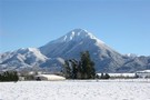
Discover Hakatere / Ashburton Lakes
The open postglacial tussocklands between the Rangitata and Rakaia Rivers make for a great winter destination.
More ▶︎

Te Araroa: The longest walk
The story of the beginnings of New Zealand's 2600km long trail and one man who has walked it.
More ▶︎
Tongariro National Park World Heritage Area
Place.
World Heritage Area. 795.96km2.
Created
11 September 201311 September 2013.
Tongariro National Park was given to the Crown by the Ngati Tuwharetoa iwi in 1887, and became New Zealand's first national park -- and the world's fourth national park.
More ▶︎
Queen Charlotte Track
Queen Charlotte Track over 4 days.
Slight detour to Punga cove accommodation
More ▶︎