Nearby
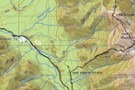
Mt Turiwhate track
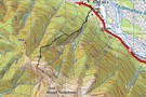
Mt Turiwhate track map
Photograph
•
Distance: less than 100m away
This map shows the gps'd route from SH73 up on to the tussock & rock main ridge leading to Mt ...
More ▶︎
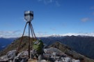
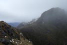
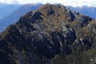
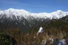
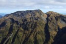
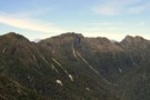
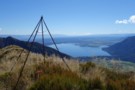
Turiwhate trig October 2020
Photograph
•
Distance: less than 100m away
A view from near the trig looking south eastward. The true highpoint of the Turiwhate Range is framed by the ...
More ▶︎
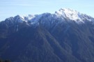
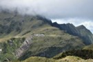
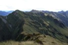
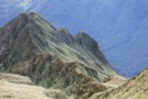
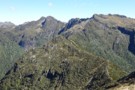
Mt Turiwhate from the Griffin Range
Photograph
•
Distance: less than 100m away
This is a July pic of the Turiwhate tops taken from the Griffin Range.
Mt Turiwhate is largely ignored by Trampers ...
More ▶︎
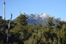
Mt Turiwhate July 2012
Photograph
•
Distance: less than 100m away
This pic was taken from Kawhaka Creek and looks east toward the summit of Turiwhate. (1373m)
Various creeks provide access up ...
More ▶︎
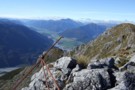
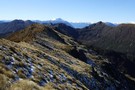
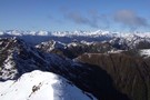
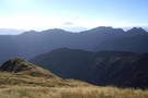
View NE from Mt Turiwhate trig
Photograph
•
Distance: 106m away
This photo was taken autumn 2010 whilst doing a traverse of the higher bumps on the Turiwhate Range. Unlike at ...
More ▶︎
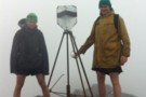
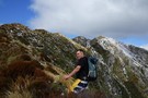
Mt Turiwhate Summit
Photograph
•
Distance: 113m away
Tate and Jared with the Trig after an entertaining climb up Turiwhate and across the tops
More ▶︎
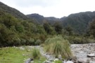
Elle dog on Mt Turiwhate track April 2014
Photograph
•
Distance: 410m away
This picture was taken about 500 metres up Grahams Creek from SH73 where the Turiwhate track leaves the creek bed ...
More ▶︎
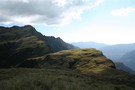
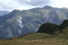
View of Turiwhate Range from the SW
Photograph
•
Distance: 747m away
This photo looking up to the crest of the range was taken from a gap in the scrub zone of ...
More ▶︎
Turiwhate Range from the South West
Photograph
•
Distance: 747m away
On Sunday I walked up Mt Turiwhate from the SW. Historically the range has usually been accessed from the NW ...
More ▶︎
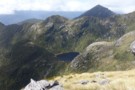
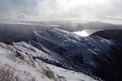
Murk on the Turiwhate tops Sept 2012
Photograph
•
Distance: 751m away
This picture looking SE shows in the right hand foreground the third bump north west of the Mt Turiwhate summit ...
More ▶︎
Turiwhate tops Sept 2013
Photograph
•
Distance: 1.1km away
This photo is of Neil B on the Turiwhate tops about 10 minutes SE of where the TL Grahams Ck ...
More ▶︎
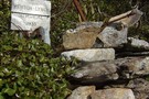
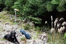
Plane Crash Memorial Mt Turiwhate
Photograph
•
Distance: 1.3km away
This photo shows the memorial to Lynch and Renton who were killed in the first fatal plane crash in Westland ...
More ▶︎
Mt Treacey Sept 2013
Photograph
•
Distance: 4.8km away
This picture of Mt Treacey in the Hohonu Range was taken from Mt Bruce Murray. You are looking at the ...
More ▶︎
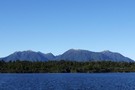
Hohonu Range from Kapitea Reservoir
Photograph
•
Distance: 5.3km away
This photo was taken from the Westland Wilderness Trail (Cycle Trail) at the Kapitea Reservoir near Kumara and looks eastward ...
More ▶︎
Hohonu Range tops August 2013
Photograph
•
Distance: 5.3km away
This photo was taken from the knob just SE of Mt Smart and looks eastward through part of the Hohonu ...
More ▶︎
Lake Ruby Hohonu Range
Photograph
•
Distance: 5.3km away
This photo taken while doing a tops traverse of part of the Hohonu Range shows seldom seen Lake Ruby. The ...
More ▶︎
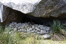
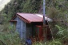
Smart Creek Rock Bivvy, Hohonu Range
Rock bivouac
•
Distance: 5.6km away
A large rock in the head basin of Smart Creek. An historic bivvy that has been used since the 1890's. ...
More ▶︎
Historic Rock Bivvy, Hohonu Range
Photograph
•
Distance: 5.6km away
This snap shows a man made rock wall at the bivvy. I've displayed a few of the many relics found ...
More ▶︎
Mt Kerr
Photograph
•
Distance: 6.1km away
Exploring the exposed tops above the Arahura RIver just before a front rolls in. Reached by an old NZFS track ...
More ▶︎
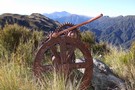
Relic from Griffin Range Serpentine Mine May 2010
Photograph
•
Distance: 6.2km away
This pic was taken at the old mine area where there are lots of relics. The perspective is looking NE ...
More ▶︎
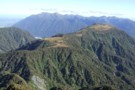
Griffin Range
Track
•
1 – 3 days. Medium. Return via same track.
•
Distance: 6.2km away
A traverse of undulating tops to the summit of Mount Griffin. Good camping next to pretty tarns, striking cliffs, and ...
More ▶︎
A closer view of the serpentine Mine
Photograph
•
Distance: 6.2km away
Perhaps a scar on the landscape but a point of interest all the same.
Griffin Tops is perhaps a place ...
More ▶︎
Griffin Creek
GPX file
•
Distance: 6.2km away
The route in to Griffin Creek Hut from the highway.
More ▶︎
Mount Griffin (1516m)
Photograph
•
Distance: 6.3km away
The Alpine Fault passes along the northern foot of the Griffin Range, resulting in cliffs that reach up to the ...
More ▶︎

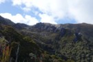
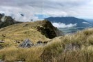
Griffin Tops
Photograph
•
Distance: 6.3km away
Looking along the tops toward Mt.Griffin.
The Serpentine mine is in view below the top of Mt.Griffin.
West of Arthurs Pass NP
More ▶︎
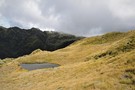
A tarn on Griffin Tops
Photograph
•
Distance: 6.4km away
On a shelf below Wilson's Knob 1291m, the southern side of Griffin Tops.
We didn't bring the Steripen so maybe ...
More ▶︎
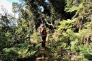
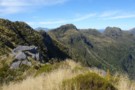
Negotiating treefall - Griffin Tops track
Photograph
•
Distance: 7.0km away
It's familiar, but climbing over on the return.
Took a way around on the ascent.
More ▶︎
Head of Griffin Creek July 2011
Photograph
•
Distance: 7.5km away
This pic was taken a few minutes along the Griffin Range route from the turnoff from the Harrington Creek - ...
More ▶︎
View SE from Mt French July 2011
Photograph
•
Distance: 7.6km away
This pic was taken from the summit of Mt French and looks across the Hohonu Ranges and the Taramakau valley ...
More ▶︎
Tops route between Lower & Top Olderog bivs Jan 2010
Photograph
•
Distance: 7.7km away
This pic was taken from the summit of the McArthur Crags. The ridge running NE away from the viewers eye ...
More ▶︎
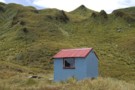
Top Olderog biv Jan 2010
Photograph
•
Distance: 7.7km away
This biv is located on the TR in the headwaters of the main branch of Olderog Creek. It is well ...
More ▶︎
Top Olderog biv
Hut
•
Basic Hut/Bivvy (DOC). Capacity: 2.
•
Distance: 7.7km away
This biv was built by the NZFS in 1971. It is located on the TR in the headwaters of the ...
More ▶︎
Glimpse of Lake Brunner from Mt French July 2011
Photograph
•
Distance: 7.7km away
This photo was taken while climbing Mt French and looks down past point 1233m, where there is a radio repeater ...
More ▶︎
Mt Alexander in Background
Photograph
•
Distance: 7.8km away
Taken from beside radio tower below summit of Mt French at point 1233
More ▶︎
Mt French
Track
•
1 day. Easy/medium. Return via same track.
•
Distance: 7.8km away
The track starts approximately 12 km east of Kumara on the Inchbonnie-Kumara Road, or 26 km from Moana following the ...
More ▶︎
View of McArthur Crags from the Newton Range Jan 2008
Photograph
•
Distance: 8.3km away
This picture was taken from just north of the Newton Range biv. I took it to show the band of ...
More ▶︎
Griffin Creek Hut
Photograph
•
Distance: 8.3km away
Yes I am sure this is the track.. I think.....
More ▶︎
Route down off McArthur Crags to Lower Olderog biv Jan 2010
Photograph
•
Distance: 8.4km away
This pic shows the SE leading spur off the top of Mt McArthur that leads down to Lower Olderog biv. ...
More ▶︎
Lower Olderog biv (aka Jade biv) Feb 2009
Photograph
•
Distance: 8.4km away
This biv is located on a bench well above the creek bed in the headwaters of Jade Creek. It is ...
More ▶︎
Lower Olderog biv (aka Jade biv)
Hut
•
Basic Hut/Bivvy (DOC). Capacity: 2.
•
Distance: 8.4km away
This NZFS biv dating from 1957 is located on a bench well above the creek bed in the headwaters of ...
More ▶︎
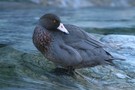
Griffin Creek - Rocky Creek
Track
•
2 – 3 days. Medium. Return by the same track.
•
Distance: 8.5km away
An isolated circuit west of Arthur's Pass along lightly used tracks and rocky riverbeds that are home to blue ducks.
More ▶︎
Griffin Creek Hut
Hut
•
Basic Hut/Bivvy (DOC). Capacity: 5.
•
Distance: 8.5km away
A small but lovingly maintained DOC hut in an isolated valley that is home to a number of blue ducks. ...
More ▶︎

Griffin Creek Hut
Photograph
•
Distance: 8.5km away
This homely hut is well maintained but not often visited.
More ▶︎
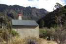
Griffin Creek hut August 2010
Photograph
•
Distance: 8.5km away
Here is another pic of the hut but this one shows Razorback Ridge in the headwaters of Griffin Creek as ...
More ▶︎
McInerney tops
Photograph
•
Distance: 9.1km away
This photo shows from Rocky Saddle through to the northern end of the McInerney tops with the Hohonu Range beyond ...
More ▶︎
Faultline on Mt Olson May 2013
Photograph
•
Distance: 9.3km away
This picture shows a fault line on the eastern side of Mt Olson (1603m)
Mt Olson is a hill in ...
More ▶︎
Taff Tor etc. Hohonu Range Feb 2019
Photograph
•
Distance: 9.6km away
I took this photo when traversing southward down the Hohonu Range.
Taff Tor which is the second high point just left ...
More ▶︎
Heart of Hohonu Range from Mt Ruberslaw
Photograph
•
Distance: 9.6km away
Taken Feb 2019 this photo looks WNW to the main Hohonu Range from beside the Ruberslaw trig.
Many of the peaks ...
More ▶︎
Eastern Hohonu River headwaters
Photograph
•
Distance: 9.6km away
This photo view is SE in to the heart of the Hohonu Range from about 4km up river of the ...
More ▶︎
Three Hohonu Peaks
Photograph
•
Distance: 9.6km away
This picture was taken in March 2013 from the Hohonu Ridge tops east of Castle Hill. i.e. This photo is ...
More ▶︎
Jade Prospectors hut at Olderog/Jade Ck confluence Feb 2009
Photograph
•
Distance: 9.6km away
This hut is known by the names of both the creeks it is at the confluence of. We used to ...
More ▶︎
Mt Ruberslaw trig beacon etc Feb 2019
Photograph
•
Distance: 9.9km away
This photo shows an historic iron pipe trig (survey triangulation beacon) that remains standing on Mt Ruberslaw, Hohonu Range. It ...
More ▶︎